Wednesday, June 30, 2021

Somewhere in Time

Stepping onto Mackinac (pronounced MackinAW) Island is like stepping back in time.  No wonder the 1980 time traveling love story, Somewhere in Time was shot on this little island.  A short, 20-minute ferry ride from mainland Michigan takes you to an island with an 8-mile circumference where life is slower-paced and time seems to have stopped many years ago.  No cars are allowed on Mackinac and the buildings on main street are somewhere between the saloon days and classy early-twentieth century.  They are colorful, tightly-packed and intricately decorated.  Horse-drawn carriages make all the deliveries necessary whether trash pick up, Amazon deliveries or a taxi-ride from the tiny airport.  Bicycles are everywhere, and watching hotel-workers carry large amounts of luggage on their handlebars was incredibly impressive.


Mackinac was reminiscent of Martha's Vineyard, where established wealth thrives and tourists jump at the opportunity to enjoy it for just a few moments.  It is certainly a bit of a tourist trap, and things are a bit overpriced, but it is also adorable and endearing.  Almost everyone we met there had been coming to the island since they were a kid, the summer getaway for all Michiganers.  One of the Yoopers we had met told us of his time in the Boy Scouts when he got to spend a week on the island raising and lowering flags and giving short tours.

Main Street, about five blocks long was seemingly where 70% of those on the island were at any given time.  Go about two blocks in any direction from main street, and you'd find another 20%.  The street teemed with people, especially during the heart of the day after day-trippers arrived and before they returned to their mainland beds.  The store fronts could be split into four categories: restaurants, souvenir shops, fudge shops and everything else.  Another Yooper had told us that Mackinac had a particular scent.  When we stepped off the boat, it hit us immediately: a combination of horse and fudge.  While it may sound unpleasant, it became part of the endearing charm of the island.

I am unclear as to why, but Mackinac is known for their fudge.  I believe there were only about eight fudge companies (remember, I said it was about five blocks long), but some of those shops had two or three store fronts on the same street!  Walking by some shops gave me a sugar high just from the wafts that came out the front door.  The art of fudge making was on full display with large marble slabs in the store windows where talented artisans mixed and shaped fudge.  It is said that if you got just one sample from each store, you'd get two pounds of fudge.  I'm not sure we made it quite that far, but I made sure I was never in want of something sweet.  Truly a treat!


We stayed in the Murray Hotel, a historic hotel dating back to the late 1800s.  As an old hotel, the rooms were near closet size, but the decor was truly perfect for the setting and just as gaudy and tacky as one would hope.  The wallpaper was covered in brightly colored birds and framed on the wall were artificial flowers.  In order to open the door to the hallway, we had to closer the cabinet where the TV slid in and out of (the TV had an entire channel dedicated to Somewhere in Time), and for the first time in our travels, we carried around a real key.  A perfect place for the setting of this historic little island.


Making the 8-mile loop around the island was high on our list, but bikes were not cheap to rent, and Jessica is very patient with my lack of comfortableness on a bike.  So, our first trip around was on foot, and we were one of the very few doing that!  The road/sidewalk goes all the way around the outside of the island.  It is flat, and often just inches from the crystal-blue-clear waters of Lake Huron.  Much of the island is a state park, and so, while main street is crowded, much of the island is forested land with little signs of humans.  Part of the road was closed off for construction, but thankfully, a cut-through path allowed us to continue and see almost all of the circumference.  Later in the afternoon, when the crowds had died down a little bit, and I was sure of our flat path, we did rent bicycles and do the loop once more because, well, that seemed like what you were supposed to do.  It was lovely - simple joys on an island that allows you to slow down and enjoy them.


I went for a walk one morning and ventured a bit more inland rather than just the coastal path.  It is nice walking on paths that are close to road width without any fear of a car running you over.  (Of course, a horse and carriage would be a horrible ending...).  There were clutters of small homes and apartments where people who work on the island live, but the big glorious homes seemed harder to find (perhaps it is like this was by design...).  Some people do live on the island year-round.  The K-12 school there usually houses about 90 students, but many of the residents of the island are there from May - September, working hard to satisfy tourists.


The Grand Hotel is stunning and of an era where big, fancy hotels were retreats of the elites.  It boosts having one of the longest porches in America, but the joys of sitting in one of the rocking chairs costs you a fee unless you are a guest of the hotel.  Outside the hotel, a sign describes the attire one needs to enter the hotel.

It is this old-world charm, this "of a different era", this "of simpler times" that makes Mackinac a true gem.  It is all of this that makes it a repeat destination for locals summer after summer, to taste the fudge, glide on a bicycle and step back a bit to somewhere else in time.


Friday, June 25, 2021

Yooper

Researching this part of our great country, visiting Michigan’s Upper Peninsula, or the UP, was a definite. Many others wanted to escape the cities this year, so our camp sites were a bit limited, but I’m so thankful we made the plans we did.


The Upper Peninsula borders several of the Great Lakes, but we spent our time on the northern shore on Lake Superior, which for all purposes looks like an ocean minus the salt.

Our first camp site was in a large state park, the Porcupine Mountains. While where our tent was located was in close proximity to others, the camp grounds themselves had rocky shores where we spent many hours on the warm rocks, dipping our toes in chilly water, reading while listening to the waves gently crash on the burgundy rocks.


The park was about as different from our first camping experience on this trip as it could be. It was a dense forest with thick green undergrowth and ferns galore. While in North Dakota we saw abundant wildlife, here we only saw chipmunks and birds, and one terribly curious and adorable creature, who after extensive internet searching, I believe is a marten.


Our first day, we hiked along a ridge overlooking the Lake of the Clouds, a narrow lake about a mile long, but only 15 feet deep. The hike provided sweeping views of the distant landscape, full of green until it met the blue up above. I can only imagine how these thick maple and oak forests look in autumn. The weather could not have been more glorious. While most of our walk was under the shade of large oaks, moments on the edge of the ridge opened up and greeted us with delightful breezes. The rock overlooks provided a perfect place for a picnic lunch and enjoyable pauses along our trek.


The next day, we hiked the Summit Peak Loop.  After the young ranger mentioned the name of the hike, I joked with her about what an intense climb it must be.  Even though the hike includes the highest peak in the park, the parking lot for the hike is about at the level of the highest peak.  The forest was beautiful: dense, lush ferns, and small swampy areas with cattails and irises.  Unfortunately, we didn't stop to take a lot of time to look at the forest because those lovely swampy areas provided the perfect breeding ground for one of my least favorite blood-sucking creatures.  So, it was a fast-paced hike with lots of slapping, but lovely views of the UP anyway.


We took another short hike, mosquito-free, by a narrow wandering river.  Along the way were short informational signs that talked about the area's history in mining, although little evidence of those mines from the mid-1800s still exist.

Our evenings were spent looking out over Lake Superior, playing cards, struggling to start a fire with few trees around to drop little limbs, and listening to conversations of those around us.  One thing I had not anticipated was the difference in accents and words used in this part of the country.  I love hearing the soft, kind words and the simple add-ons of phrases, and the drawn-out Os.  One local told me it probably wasn't too different from my own southern heritage.  I told him I felt the sentiment and mannerisms were very similar, but the language was vastly different.

Our next camp site was in a big campground and our tent site was on the beach, overlooking Lake Superior.  We dreamed of watching the sunset and sunrise over the water through the open door of our tent.  But then, weather happened.  The forecast predicted rain for a solid 24-hours including when we would be setting up our tent.  Not only that, but there was a gale warning for a full day in the area with threats of wind gusts of 30+mph and possible wave swells of up to 11 feet.  Then, our kayaking tour that swore they didn't cancel until the day of canceled well over 24-hours in advance.  Oh, and did I mention the high for these days was about 50?  So, we wimped out and booked a hotel in the area that had a hot tub.  While sipping our wine in the hot tub, we laughed at our circumstances.  Yes, waking up on the beach sounded lovely, but not in the conditions we were given, so once again, we made the most of our time, but just adjusted our plans a bit.

These changes once again provided us with a little more free time, so we enjoyed some stops along the three hour drive between Porcupine Mountains and Pictured Rocks.  First, we stopped in the small town of Marquette, a shipping town with history of railroads bringing iron ore out to big ships that then dispersed it around the world.  A local told us that in the winter the whole harbor freezes over and they all enjoy using it as a skating rink.
Ore Dock

We pulled over to a roadside attraction, a sculpture garden created by one man. Lakenenland was started by a man, who self admits that he had a drinking problem and so he chose to spend his time instead creating works of art and placing them around a 37-acre park he purchased and now allows people to drive or walk through free of charge. The metal sculptures varied from alligators to rock bands to supporting labor unions to purple elephants. There was also a bog walk with hidden animal sculptures. A truly fascinating roadside attraction, and if you want to hear this glorious accent, you can listen to the creator of this unusual place.


Munising (with a long U) is a teeny-tiny town that averages about 200 inches of snow each year. Many road signs include instructions for snowmobiles as well. There is a lot of fishing (whitefish) and a fair amount of tourism for the Pictured Rocks. On our one full day in the town, the wind was powerful, and my weather app said that the windchill was in the upper 30s. The sun did come out in the afternoon, but it was still fairly brutal, so we did a very short hike to see one of the many area waterfalls, went to several scenic overlooks to see the stunning rock cliffs and then went in a couple of the few shops in town. One of which had a wine tasting of local wines. They were all fairly sweet, but it certainly wasn’t a bad place to enjoy part of a frigid day, sipping local specialties.


For dinner, we stopping by the local establishment, the Barge Inn, and soon found ourselves engrossed in conversation with fellow tourists and locals alike. I loved learning some of the local lingo, especially the term “trolls,” a derogatory term used to describe those people who live “under the bridge,” also known as main land Michigan.  We also learned about the famous food, pasties.  The area, known for mining had once been full of expert miners from Cornwall, and so the Cornish pasties, very similar to meat pies became common.  The Yoopers (U-Pers) are a proud people. It is mostly hard-working folks in the mining, shipping or lumber industries. It is rural, small towns scattered between National Forests even a National Wildlife Refuge. It is heavily wooded with a few scattered fields, but very little appears to be farmed. There are some rolling hills, but the southeastern part is very flat and even marsh-like.

The Pictured Rocks National Lakeshore is a truly stunning lakeshore along Superior with rock formations and rock cliffs right up against the water.  As they are right up against the water, the best way to see them is from the water.  We had signed up for a 6-hour kayak sunset tour of the rocks, but the weather changed that into a 3-hour morning kayaking tour.  I would love to come back and go further along the lakeshore while the afternoon sun hits it, but we enjoyed rowing up the colorful rock formations that are millions of years old, going into small caves and watching young seagulls huddle on the rock faces.


There is said to be lots of wildlife in the UP: black bears, moose, wolves, bobcats, fishers, porcupines, etc.  We were unlucky with mammals, unfortunately.  We did see sandhill cranes that winter in Florida and enjoy spring and summer months up here.  We only saw them along the roadside, enjoying marshy areas.  Their large brown bodies often stood out from a long distance, but it wasn't until we were upon them that we could truly tell what they were.  We were most excited to see a porcupine.  Many of the locals were surprised that we hadn't seen one at all, especially along the roadside.  It was near the end of our UP journey that we finally saw them.  Although we were disappointed that they were much flatter than we hoped, technically, we did see a porcupine!

Despite some uncertain weather, I thoroughly enjoyed my time in the UP, enjoying beautiful scenery, a slower pace of life, and friendly Yoopers!

Sunday, June 20, 2021

Minnesota

I have had the pleasure of visiting Minnesota a couple of times before, thanks to the fact that a dear college friend, Melissa moved up to this part of the world.  However, Jess had not yet been here, so we needed to make sure to spend some time in this fair state.  In researching, I truly wanted to see the Boundary Waters between America and Canada, but I could not really figure out how to do that properly.  It seemed that we needed a boat and a guide to make it possible, and well, the van holds a lot, but we didn't pack a boat.  So, we took a different route.

As in North Dakota, Minnesota seemed to be searching for some roadside attractions, and so between Fargo and Minneapolis, we encountered many fabulously large attractions.  There was the World's Largest Prairie Chicken (if you don't know what that is, don't worry, I still don't really understand it).  There was America's Largest Viking Statue of Big Ole, but why he holds a sign that says "Birthplace of America," I haven't yet figured out.  And of course the World's Largest Crow which stood proudly at the center of a Memorial Park.  Again, I'm not totally sure...  But my favorite was probably the Largest Ball of Twine (Built by One Person).  It was in the tiny town of Darwin which was proud of their claim to fame.  The ball of twine which took this man twenty-seven years to build was on the town flag and proudly displayed in its own building.  There was even a Twine Ball Inn (which I'm not sure is actually still in use...).  Some of our drive took us on two-lane roads, my very favorite way to see America.  The towns each had a sign with their population number on it.  While most were in the high hundreds or low thousands, there were several that could easily be counted to, like 34.  


I know it is hard to see... but this is the ball of twine...

One attraction just outside of Minneapolis, I had already been to twice before, but it is sort of a right of passage for this area.  The Mall of America was a big deal when it was built.  I remember reading about it as a kid, and I believe even watching the Mighty Ducks visit the mall.  It is a spectacle for sure.  Not only is it a huge, multi-story mall, but there is a small theme park in the middle.  We rode the indoor roller coaster, because again, it is a right of passage, right?

We ventured into Minneapolis to spend a few days, but were surprised by what we found.  I had been warned by a friend at home about what was still going on in Minneapolis, and someone we met in Fargo gave a similar warning.  I listened, but felt like it was a big city, we would be aware of our surroundings and would be just fine.  What we discovered, though, was a seemingly empty city due to a combination of COVID restrictions and continuing protests. Restaurants were closed, a book store I wanted to visit was closed, art museums were open some days, but not Wednesdays.  Our hotel, while we felt safe within, was even closed up with the restaurant, bar and pool all closed.  So, while we felt safe, we quickly realized there would not be much for us to do in town, so we adjusted our plans, all for the best.

Researching Minneapolis ahead of time, there were a couple things I wanted to see before we left town. The first was the Mary Tyler Moore statue. The story of that bold, working single gal of the 70s took place in Minneapolis (even though it was filmed elsewhere). The iconic scene where she threw up her hat took place on a busy Minneapolis street corner. About 20 years ago, when the statue was put in place, Mary herself was there, bringing with her thousands of hats so that the whole crowd could throw hats in the air together.

The Minneapolis sculpture garden was also a place I wanted to stop, and it did not disappoint. Unique, huge statues were scattered around the park, and made for some fun photo shoots.


With our bonus day in Minnesota, we decided to head north to the scenic coastline, a place truly more our speed anyway. The Land of 10,000 Lakes likes to claim that they have more coastline than California, Hawaii or Florida. It depends, it seems on just how you define coastline, but if you include coastline of a lake, Minnesota far exceeds the other three. No matter what, the coastline of northern Minnesota that lines Lake Superior is stunning. 

We went to Tettegouche State Park and went for a short hike to see a stunning waterfall, one of the many in the area.  Palisade Head was next, providing sweeping views of the seemingly endless blue water. It is astounding to see the blue water meet the blue sky, but know that it is only a lake, not an ocean. Iona’s Beach was a lovely quick stop. It was a beach made up of small pink rocks. When the waves hit just right, the beach “sings”. As the waves retreat, the tiny rocks “tinkle” hitting one another creating a unique instrument of nature’s creation.

Tettegouche State Park

Pallisade Head

Iona's Beach

Just driving along the coastline was a treat. It was very reminiscent of our time in Maine with lush greenery meeting a rocky coastline of endless blue. One of my favorite sites were the roadside collections of lupines. I had dreamed of seeing them in Maine when we went a few years ago, but we were a bit late for them, and I was terribly disappointed. As a kid (and a teacher), one of my favorite picture books is Miss Rumphius. It tells the story of a woman who was told by her grandfather to do three things in her life: travel the world, live by the sea and make the world more beautiful. She struggles with the last one, but finally decides to scatter a large amount of lupine seeds throughout her small town. A new dear friend of mine, Mr. Lou, who visits our school and shares stories with our students, brought lupine seeds (to go along with the story, one of his favorites as well) for us all the last time he visited our class in person, just before shut down. They have reseeded themselves in my own back yard, but the climate does not seem to be right to make them want to bloom. No matter what, seeing these lupines along the side of the road, in deep purple with small scatterings of pinks and whites filled me with joy.

We spent the night in Duluth, a relatively small town with a bustling sea port and beautiful views of Lake Superior. I was sorry for the reasons that changes needed to be made in our trip, but I’m so thrilled with the opportunities those changes provided.

Tuesday, June 15, 2021

North Dakota

Few people I know have been to North Dakota, and it seems that few people ever really travel to this state.  But that doesn't mean that there is not a lot to be seen here, at least by some standards.

Jessica and I drove just about the entire length of the state.  Theodore Roosevelt is on the far western side of the state, and our next destination, Fargo, was on the Minnesota border.  This is a large state, but it is one of the very smallest as far as population goes.  In fact, there are fewer than one million people in this great state.  

After the buttes of western North Dakota, there are open expanses, vast prairie lands, pastures, and wind farms that take up the majority of the landscape for hours on end.  But the great people of North Dakota knew that there needed to be something to attract people here, so they created HUGE (pun-intended) attractions.  There was Salem Sue, the world's largest holstein cow.  Sandy, the world's largest sandhill crane was created by a farmer who enjoyed the creative challenge.  Dakota Thunder, the world's largest buffalo (bison) sits at the edge of a Frontier Village and the National Buffalo Museum.


A few weeks ago, my mom saw this story on CBS Sunday Morning.  In case you don't have the eight minutes to watch it, I'll give a brief recap.  For years, the small town in Northern North Dakota, Rugby, had claimed to be the center of North America.  But, one night, after a few drinks, the people of the small town of Robinson, a little south, decided that in fact, the geographical center of North America ran right through the very bar they were in.  To settle the dispute, a scientist plugged in latitude and longitude numbers and discovered that the geographical center of North America happened to be in the small town of Center (yep), North Dakota.  Luckily, Center was also the one closest to the interstate.  We made a detour to Center, and shockingly struggled to find the marker, a few miles outside of town, but after asking some very friendly locals, we were able to step foot in the geographical center of North America.


So, after a full day of driving and many very exciting stops along the way, we made it to Fargo.  While Trip Advisor doesn't list many attractions here, there is a lively vibe to Fargo.  It is a hipster town, a blue dot in a red state, a young city with a big heart.  Once again, everyone we encountered greeted us with warm welcomes going above and beyond.  Two friendly locals, after learning where we were from asked, "Why are you here?"  I'm not sure they are used to people visiting, but that does not mean they don't know how to host!

We stayed just a few blocks from the adorable downtown street of Broadway which stretches about five blocks long with a little of the entertainment district expanding just a bit beyond.  These blocks are full of funky new restaurants, breweries, ice cream shops, collectibles stores and scattered businesses.  Painted benches, wall murals, uniquely painted bison statues, creative bike racks and outdoor seating options graced the road adding flair.  


The border here between North Dakota and Minnesota is a river flanked on both sides by green space with a great pathway through it.  I enjoyed a walk in the morning and was shocked by the wildlife right here in the bustling city!  Rabbits scurried across the path in front of me, a turkey wallowed in a dirt spot in the middle of the grass, a groundhog (perhaps marmot) sat perfectly still on a log, camouflaging himself and what I believe was a very young beaver hurried to hide in the bushes.

Making the most of our time here, we enjoyed eating!  A hip restaurant in a basement off of an alleyway in an old boiler room provided me with a divine candied bacon BLT.  Breakfast from a coffee shop allowed us to taste the famous caramel rolls.  (Why do we not have these cinnamon-bun like creations drenched in caramel?)  Rolled ice cream from a Thai shop reminded us of our time in Asia where we first had rolled ice cream.  My first ever cidery was a true delight!  Not enjoying beer, I have found a real liking of cider, but it is not always readily available in the south.  This local cidery was a true delight for me!  One of their creations, Trail Magic, is different every year as it is created from donated apples from locals.  Tacos, ordered off of a menu printed on an old vinyl wrapped up our culinary delights in this fair city.


Caramel Roll

Before leaving Fargo, we had to make a quick stop by the visitor center to see the famous wood-chipper.  If you've seen the movie, Fargo, you know what I'm talking about.  If you haven't, well, don't ask...  As it turns out, the city didn't always accept their connection to the Coen Brothers film, but after the city decided to embrace the connection, they tracked down the movie prop and it is certainly a draw for the tourists!

I asked the locals we encountered about winter.  They all sort of sighed before answering.  It sounds truly brutal, with much of the day in darkness and months with snow on the ground.  It is only the truly hearty who can survive here, and perhaps that is why their hearts are so big!

Sunday, June 13, 2021

Theodore Roosevelt National Park

When I told people I was coming to North Dakota, they almost all said, “Oh, Mount Rushmore!” I would say, “No, I’ve been there, but that’s South Dakota.” They would say, “Oh, the Badlands!” I would once again say, “No, that’s South Dakota.” (More on that in a minute.) Then, they would say, “Well, what is in North Dakota?”


Before planning for this trip, I probably would have had similar questions. Very few people I know have been to North Dakota, but that’s part of what makes it so intriguing to me! Thankfully, Niki, our 50 by 50 inspiration, had been here and had tips galore to share. Her advise steered us to a little known National Park. Theodore Roosevelt, our conservationist president, loved this part of the country. He ranched here, escaped here, and learned about conservation here. It is because of him that we have an expansive National Parks system, and so it seems only fitting that this park was named after him. 


This National Park is not a massive one. An hour and a half around a loop drive can show you a majority of the southern part of the park, but we all know that a drive around means you miss out on so much more.

One of my first questions to a ranger was about the Badlands. I have visited the Badlands National Park in South Dakota, and yet, this area had also been referred to as the badlands, so I asked for clarification. It seems there are several sections of badlands in the Dakotas, named such, I believe, for their lack of ability to harvest nor pass through on ox and wagon. The ranger proudly boasted though, that the badlands here are the oldest.

Jessica and I both love camping and hiking. There is something rejuvenating about it. So, we decided from the start that we wanted several nights at the park. Setting up our tent, blow up mattresses and chairs always takes a little bit of effort, so you want to make sure you’ve got time to really enjoy the home you just built. Our site had bison droppings and a snake slithering toward it when we arrived, truly welcoming us properly. My favorite times at our campsite were our evenings of playing cards, strolls around the campsite, watching stars appear, reading with no distractions and watching bison wander calmly through. Camping allows for the smaller pleasures in life to become the highest priorities.

The weather made our time in the park a little more trying with highs in the upper 80s and 90s, two full days of wind gusts in the upper 20s, and strong thunderstorms two nights (one with a tornado watch), but we made the most of it and found lots to enjoy in this great park.  Like most places with lower humidity, shade made a huge difference, but the terrain of this park did not provide a lot of shade. There were trees, yes, but aside from the cottonwoods in our campsite, they were more sporadic, and also quite “limby,” so getting under their shade was problematic.

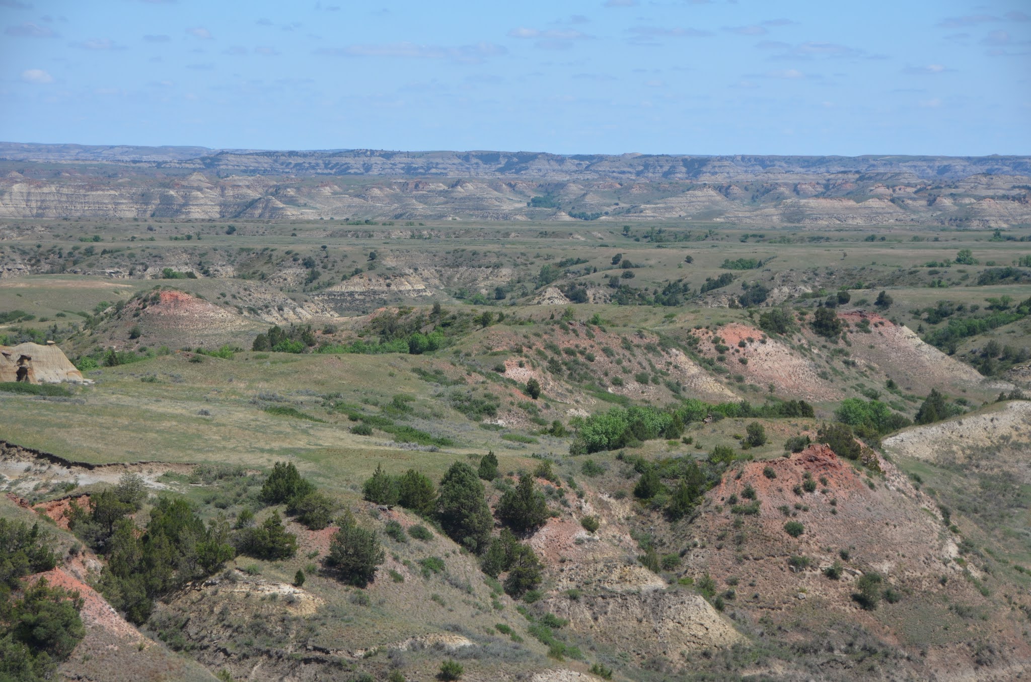
The park is made up of a seemingly endless amount of buttes as far as the eye can see. A butte may appear like a mountain, but the difference in their categorization has to do with how they are formed. Mountains grow up from the ground while buttes are broken down from erosion. So, at one point, all of this land was the same height, but years of erosion have created buttes and canyons. The tall buttes have clearly distinguishable lines of color showing age and periods of erosion.

Wildlife in the park was plentiful! There are no bears in the area, so that made life a little easier taking away that fear. Bison were everywhere, sometimes on their own, sometimes in large groups of thirty or more. They wandered across the road and through campsites, showing that this land was theirs and not ours. We did some research and learned that these are bison, not buffalo, even though for years, Americans have used the terms interchangeably. 


Prairie dogs were in huge supply; their towns were marked on the map of the park. Some of my favorite parts of hikes were the walks through their towns. They scurried about, chirped at us and wagged their tails before going back into their burrows. This is a favorite video of ours, so we walked through the towns calling “Allen” and “Steve,” but no one responded. Researchers have determined that prairie dogs have a complex language system and even have different sounds for color and number. We heard many a variety of chirps and squeaks! 


We spotted deer and rabbits (one that even hopped toward me on the path before stopping to scratch his ear within a yard of me, so I almost gained a pet bunny!). Prong-horns were a common site as well. Through some research, we learned that they are not actually antelope. While they look fairly similarly, antelope are of a different genetic make up found in Africa. A major difference is that antelope have antlers (that come and go), but prong-horns have horns. So, the classic song has two out of the three animals named incorrectly. 


One of our favorite creatures to spot was not an uncommon one, but they are rare to see in the wild. When this became a park in 1954, a few of the horses living here eluded capture. Their descendants are now carefully managed, but still remain wild and free to roam the park. There were birds a plenty, and they happily sang throughout the day. Crickets, too, usually an evening sound, could be heard throughout the day across the grasslands. We saw a snake, but thankfully at a safe-distance and with no visible rattle. We heard coyotes at night, but never saw them. And the elusive porcupines kept to themselves.

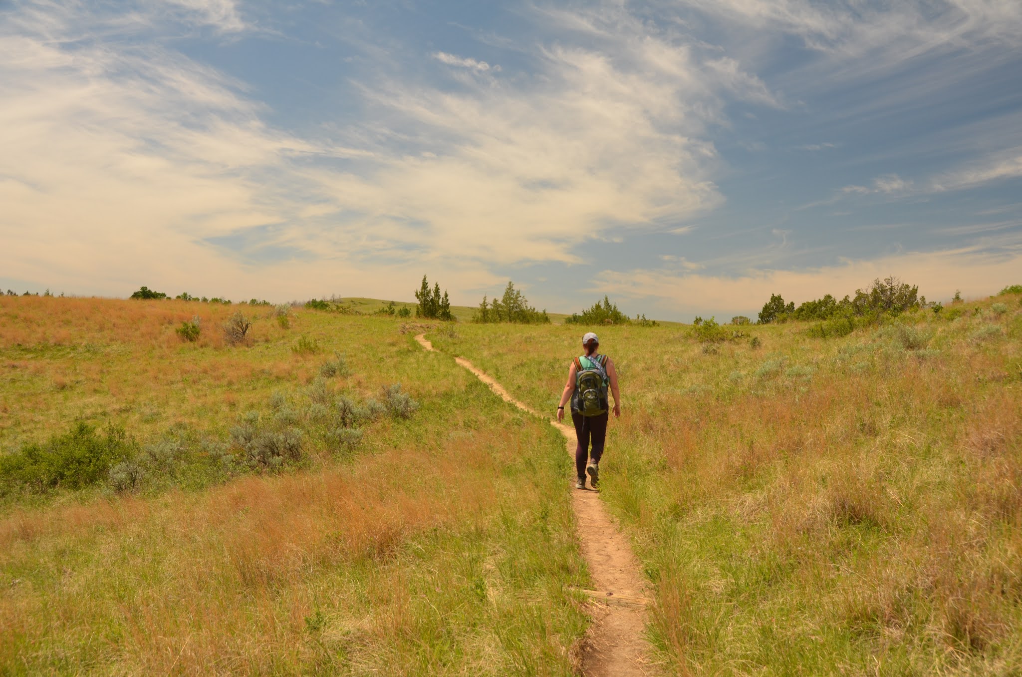
Our first hike was one from Peaceful Valley Canyon. We had to cross the Little Missouri almost immediately (little being a key word). It was no more than ten yards wide and at its deepest was about a foot and half deep. So, besides the difficulty of taking on and off our boots, it was pleasantly refreshing. The rivers here are muddy, because of continuous erosion. We walked through prairie dog towns and winded through the valley of the buttes, but perhaps unwisely we chose the ten mile loop instead of the five. Parts of the trail were tricky, crossing over tiny muddy tributaries, but mostly, it was fairly flat, walking through sage brush and prairie grasses. The most remarkable part of the trail was after just a slight climb we ended up on a prairie plateau with nothing visible for as far as the eye could see. It was a drastic change from the desert/tundra-like valley we had just walked through. It was also a reminder that this whole area at one point had been like that. The tall land provided us with sweeping views of the landscape and made the hot long trek well-worth it.


The petrified forest was another part of the park that we wanted to see, and it did not disappoint. The starting point for the trail is a little out of the way, along a dirt road that is not accessible after heavy rains. There are two small sections of the park that are parts of petrified forests, and we chose to visit the southern one. For about a quarter of a mile along the trail, you find petrified tree stumps and logs littering the ground. It was fascinating to see, and mind-boggling. Chips of “wood” are scattered about but if you touch them or attempt to lift them, you see that in fact, they are stone, despite their appearance. From a little internet searching, what I understand is that this area was once (millions of years ago) a warm climate with lots of water, not too dissimilar to the Everglades. Heavy rains buried the trees under lots of mud, depriving them of oxygen which helps them to deteriorate. Instead, minerals that help in rock formation attached to the trees and slowly, while keeping the appearance of trees, they turned to stone.


The one near perfect day that we had, with clear skies and highs in the mid-70s we should have spent hiking, but we chose a different rejuvenating option. We chose to have a lazy start to the day, then spent the afternoon with our chairs down by the river, watching bison doing the same thing on the other side. We chose to read, they mostly lazed about and tried to rid themselves of the flies. Sometimes just being is the best way to enjoy nature.


We spent more time in the town of Medora than we originally planned because of the weather. Niki had described it as “a sweetheart of a town,” and she was not wrong. Year-round it boasts a population of about one hundred twenty people, but that swells during the summer months. There are about a dozen gift shops, ice cream parlors, fudge shops, a candy shop, a handful of restaurants and a putt putt course and playground perfectly themed to the area. An art gallery and small museum about the inventor of Mr. Bubbles was a great deterrent on a hot blustery day. There is a large manor where the founder of this town, a wealthy Frenchman and his wife (who the town was named after) once lived. There also, shockingly, is a booming theatre industry, where, during the summer months, multiple performances occur each day in multiple venues. On a particularly hot blustery day, we chose to spend $15 to sit in air conditioning for an hour, and enjoyed it much more than we anticipated. A Theodore Roosevelt expert, and look-alike, shared knowledge of the President, his love for this part of the country, and interacted with the audience in a truly captivating way. We missed out on the ever popular Medora Musical, but then again, we must leave something to come back to!

Playground in Medora

Everyone that we met in this town blew us away with their kindness. The shop-owners, wait staff in restaurants, and rangers all went above and beyond, carrying on conversations and greeting us with warm, genuine smiles. The woman in the office for the Roosevelt Presidential Library, where we sort of accidentally inserted ourselves, could not have been friendlier and shared information with us about the upcoming build (scheduled to open in 2025). The gentleman in the candy shop led us to the Theodore Roosevelt play along with other helpful hints.

On our last day, we chose to drive an hour to the North Unit of the park, still under the same name, but a total separate piece of land. More buttes, vast landscapes, and canyons formed by the Little Missouri greeted us in the North. There are supposedly a herd of long-horns there as well as big horned sheep, but they wisely sought refuge elsewhere in the heat of the day. Cannonball Canyon was a unique geological area where, somehow, of which I still don’t understand, round, reddish rocks have formed and appear to litter the ground. 

We chose a four-mile loop hike in the park that took us through strikingly different landscapes in a short amount of time. Starting at the base of the buttes, we ended up climbing through a dense forest before arising on top of a butte with incredible views. A lookout point shows where the river takes a sharp curve because an ancient glacier blocked its way. And now the slow moving river floods frequently providing a perfect place for cottonwood trees to thrive.


On our last night in the park, we drove further into the park to watch the sunset from a high peak, Buck Hill. The light danced across the canyons and buttes, creating soft golden hues. Anytime I get to watch the sunset seems like a gift, and watching it from such a stunning vista was a lasting gift. Not only was the view and the color of the sky incredible, but the amount of wildlife we saw on the road to and from added to the excitement. A herd of bison, including many young ones crossed on the road in front of us. Turkey and deer used a similar crossing spot. Horses seemed to know that their silhouettes were best admired in the setting sun, and so they strutted around and did their best to make drivers stop and notice them. An owl swooped low on the road just in front of us, but the porcupine stayed hidden. 


I’m not sure if and when I’ll make it back to Theodore Roosevelt National Park, but I’m so very thankful I’ve gotten to see the beauty it provides of this unique landscape and thriving wildlife. Let me know when you’re ready to come, I’ll happily help you plan your trip!